This page will be used to pass information related to Hurricane Ian. Updates will be posted in chronological order.
Monitoring & Preparing for Hurricane Ian
The Sea Pines CSA Maintenance Department will begin normal storm preparations which include lowering lagoon levels throughout the community, securing items at our managed areas, and ensuring Sea Pines CSA drains and outfalls are clear. We ask Sea Pines property owners, guest and visitors to please make sure you have your hurricane plan in place, begin to prepare your property, and follow any advice given by local, state or government officials.
We will continue to keep you updated as we receive information via our communication resources:
NEW! Sea Pines CSA Information Hotline 1-843-671-7804: This phone line will play a recorded message with pertinent updates.
Communications from Sea Pines CSA should be secondary to the messages passed from government officials via local TV, radio and emergency management websites. Please monitor local radio and television stations and follow the instructions of emergency officials.
Register for email and text alerts from the BCSO through Nixle by visiting https://local.nixle.com/register/ or text your ZIP CODE to 888777 for mobile alerts
Hurricane Ian made landfall over the northern South Carolina coast this afternoon and is moving away from our area.
Sea Pines CSA Operations Update
The Sea Pines Pass Office, Sea Pines entrance gates, security, Welcome Center, and our security dispatch phone line at 843-671-7170 are all operational at this time. Sea Pines Maintenance staff and additional Sea Pines Security staff will remain on-site throughout the duration of the storm to ensure we can continue to respond as needed, conditions permitting.
There is some beach erosion so our staff will be checking each of our boardwalks as the tide falls and we will make repairs as needed beginning next week.
We will continue to monitor lagoon levels through the afternoon as well as continue cleanup efforts with our employees and contractors into next week.
Reopenings:
The Sea Pines Forest Preserve, Six Oaks Cemetery and Tower Beach will reopen tomorrow, October 1 at 7AM.
Sea Pines daily visitor gate pass sales at both gates will resume at 7:00 AM tomorrow, October 1st.
Sea Pines CSA Administration Office, Sea Pines ARB and the Sea Pines Community Center will resume normal operating hours on Monday, October 3rd.
COLUMBIA, S.C. – Governor Henry McMaster will hold a media briefing with state emergency management officials today, Friday, September 30 at 12:30 PM. The governor will update the public on Hurricane Ian’s impact on South Carolina.
Friday, September 30, 2022 @ 9:30 AM
Hurricane Ian Update From The National Weather Service
Rain and Wind Increasing as Hurricane Ian Approaches the South Carolina Coast
Hurricane Ian is a Category One hurricane expected to make landfall in the Hurricane Warning area this afternoon. A Storm Surge Warning and Hurricane Warning remain in effect for our area.
Overview:
At 800 AM EDT (1200 UTC), the center of Hurricane Ian was located near latitude 31.4 North, longitude 79.1 West. Ian is moving toward the north near 9 mph (15 km/h). This general motion with an increase in forward speed is expected this morning, followed by a
turn toward the north-northwest by tonight. On the forecast track, the center of Ian will approach and reach the coast of South Carolina today, and then move farther inland across eastern South Carolina and central North Carolina tonight and Saturday.
Maximum sustained winds remain near 85 mph (140 km/h) with higher gusts. Little change in strength is expected before Ian reaches the coast later today. Rapid weakening is expected after landfall, and Ian is forecast to become an extratropical low over North Carolina tonight or on Saturday. The low is then expected to dissipate by Saturday night.
Hurricane-force winds extend outward up to 70 miles (110 km) from the center and tropical-storm-force winds extend outward up to 485 miles (780 km).
Due to a variety of hazards, travel is not recommended today in the Hurricane Warning area, especially near the coast.
Update from Sea Pines CSA: Monitoring & Preparing for Hurricane Ian
The Sea Pines CSA Maintenance Department has made storm preparations and is prepared to respond to storm-related events.
Stormwater System Update: In order to get ahead of the potential heavy rainfall, staff have placed large portable high-volume dewatering pumps in strategic locations throughout the community to assist in lowering lagoon levels. These pumps will remain running as long as it is safe for our staff to operate them throughout the storm. These pumps will also be used after the storm to assist in the removal of stormwater from the community.
We continue to actively monitor the tidal control structures on our lagoon system to prevent as much tidal inflow as possible. We continue to actively manage the Lawton Canal pump station to move water out of the community.
Sea Pines CSA Administration office, Sea Pines ARB and the Sea Pines Community Center are closed and will remain closed until further notice.
The Sea Pines Pass Office, Sea Pines entrance gates, security, Welcome Center, and our security dispatch phone line at 843-671-7170 are all operational at this time. These locations will remain staffed throughout the storm, unless storm conditions threaten the safety of staff. We will notify you in advance if these services need to be modified due to storm conditions.
Access to The Sea Pines Forest Preserve and Six Oaks Cemetery are currently closed.
All Sea Pines CSA construction activities and work performed by CSA contracted services providers ceased Thursday afternoon. Timing on when work will resume in these locations is based on storm impacts.
Parking Lots along Power Line Easement:
To continue to allow Santee Cooper unobstructed access to the major transformer lines in Sea Pines, please do not park vehicles in lot numbers 1, 2, 3, 4, 6, 8, 10.
Use extreme caution or avoid using the leisure trails within Sea Pines as we are receiving reports of fallen limbs and debris.
As the storm approaches, our property owners, guest and visitors are asked to remain indoors and too stay off of the roadways in Sea Pines.
Should stormwater inundation occur, please shelter in place until waters have receded.
If you must travel this afternoon through tonight, avoid areas of standing water and downed trees across a roadway.
Sea Pines Maintenance staff and additional Sea Pines Security staff will remain on-site throughout the duration of the storm to ensure we can continue to respond as needed, conditions permitting.
Tower Beach access and facilities are closed as of today, September 30th and will reopen once conditions permit.
Sea Pines daily visitor gate pass sales have been discontinued as of 7:00 AM today, September 30th.
Communications from Sea Pines CSA should be secondary to the messages passed from government officials via local TV, radio and emergency management websites. Please monitor local radio and television stations and follow the instructions of emergency officials.
We will continue to keep you updated via our communication resources:
NEW! Sea Pines CSA Information Hotline 1-843-671-7804: This phone line will play a recorded message with pertinent updates.
We will continue to keep you updated as we receive information or need to modify our services, but in the meantime, we ask you to prepare in advance of the storm, stay safe and stay tuned to weather alerts and follow trusted sources of information.
Register for email and text alerts from the BCSO through Nixle by visiting https://local.nixle.com/register/ or text your ZIP CODE to 888777 for mobile alerts
At 5:00 PM EDT, the center of Hurricane Ian was located about 240 miles south of Charleston, South Carolina. Ian is moving toward the north-northeast near 10 mph (17 km/h). A turn toward the north is expected tonight, followed by a turn toward the north-northwest with an increase in forward speed Friday night. On the forecast track, Ian will approach the coast of South Carolina on Friday. The center will move farther inland across the Carolinas Friday night and Saturday.
Maximum sustained winds have increased to near 75 mph (120 km/h) with higher gusts. Ian could slightly strengthen before landfall tomorrow, and is forecast to rapidly weaken over the southeastern United States late Friday into Saturday.
Hurricane-force winds extend outward up to 45 miles (75 km) from the center, and tropical-storm-force winds extend outward up to 415 miles (665 km). Kennedy Space Center Tower 1 recently reported a wind gust to 89 mph (145 km/h). The estimated minimum central pressure is 986 mb (29.12 inches).
Visit the National Hurricane Center website at hurricanes.gov for additional forecast information on Ian.
Thursday, September 29, 2022 @ 2:15 PM
Update from Sea Pines CSA: Monitoring & Preparing for Hurricane Ian
The Sea Pines CSA Maintenance Department has made storm preparations and is prepared to respond to storm-related events.
Stormwater System Update: In order to get ahead of the potential heavy rainfall, staff have placed large portable high-volume dewatering pumps in strategic locations throughout the community to assist in lowering lagoon levels. These pumps will remain running as long as it is safe for our staff to operate them throughout the storm. These pumps will also be used after the storm to assist in the removal of stormwater from the community.
We continue to actively monitor the tidal control structures on our lagoon system to prevent as much tidal inflow as possible. Finally, we continue to actively manage the Lawton Canal pump station to move water out of the community.
The Sea Pines CSA Administration office, Sea Pines Community Center and Sea Pines ARB office WILL BE CLOSING AT 2:30 PM TODAY, SEPTEMBER 29TH. These offices will be closed on Friday, September 30th, and will resume normal operating hours on Monday, October 3rd.
The Sea Pines Pass Office, Sea Pines entrance gates, security, Welcome Center and our security dispatch phone line at 843-671-7170 are all operational at this time. We will notify you in advance if these services need to be modified due to storm conditions.
Access to The Sea Pines Forest Preserve and Six Oaks Cemetery are currently closed.
All Sea Pines CSA construction activities and work performed by CSA contracted services providers will cease Thursday afternoon. Timing on when work will resume in these locations is based on storm impacts.
Parking Lots along Power Line Easement: To continue to allow Santee Cooper unobstructed access to the major transformer lines in Sea Pines, please do not park vehicles in lot numbers 1, 2, 3, 4, 6, 8, 10.
Use extreme caution or avoid using the leisure trails within Sea Pines as we are receiving reports of fallen limbs and debris.
If you must travel this afternoon through tonight, avoid areas of standing water and downed trees across a roadway.
Sea Pines Maintenance staff and additional Sea Pines Security staff will remain on-site overnight and throughout the duration of the storm to ensure we can continue to respond as needed, conditions permitting.
Tower Beach access and facilities will close beginning tomorrow, September 30th and will reopen once conditions permit.
Sea Pines daily visitor gate pass sales will be discontinued as of 7:00 AM Friday, September 30th
Communications from Sea Pines CSA should be secondary to the messages passed from government officials via local TV, radio and emergency management websites. Please monitor local radio and television stations and follow the instructions of emergency officials.
We will continue to keep you updated via our communication resources:
NEW! Sea Pines CSA Information Hotline 1-843-671-7804: This phone line will play a recorded message with pertinent updates.
We will continue to keep you updated as we receive information or need to modify our services, but in the meantime, we ask you to prepare in advance of the storm, stay safe and stay tuned to weather alerts and follow trusted sources of information.
Visit the National Hurricane Center website at hurricanes.gov for additional forecast information on Ian.
Thursday, September 29, 2022 @ 1:30 PM
Governor Henry McMaster to Hold Briefing on Hurricane Ian at 4:00 PM
Hurricane Ian Expected to Make Landfall in South Carolina Governor McMaster, State Officials to Hold Media Briefing at 4:00 PM
Live event will begin:
Sheriff Tanner To Hold Press Conference Today at 3:00 PM
The Beaufort County Sheriff’s Office will hold a press conference today, Thursday, August 29, 2022, at 3 pm to discuss Hurricane Ian’s preparation and response.
HURRICANE WARNING ISSUED FOR THE ENTIRE COAST OF SOUTH CAROLINA
At 1100 AM EDT (1500 UTC), the center of Tropical Storm Ian was located about 25 miles north-northeast of Cape Canaveral, Florida. Ian is moving toward the north-northeast near 9 mph (15 km/h). A turn toward the north is expected late today, followed by a turn toward the north-northwest with an increase in forward speed Friday night. On the forecast track, Ian will approach the coast of South Carolina on Friday. The center will move farther inland across the Carolinas Friday night and Saturday.
Maximum sustained winds have increased to near 70 mph (110 km/h) with higher gusts. Ian is expected to become a hurricane again this evening and make landfall as a hurricane on Friday, with rapid weakening forecast after landfall.
Ian is a large cyclone. Tropical-storm-force winds extend outward up to 415 miles (665 km) from the center. A NOAA CMAN station at the Saint Johns County pier in Saint Augustine Beach recently reported a sustained wind of 53 mph (85 km/h) and a gust of 61 mph (98 km/h).
The estimated minimum central pressure is 987 mb (29.15 inches).
Visit the National Hurricane Center website at hurricanes.gov for additional forecast information on Ian.
Thursday, September 29, 2022 @ 6:00 AM
Hurricane Ian Update From the Charleston National Weather Service
What Has Changed: Ian now a tropical storm. Intensity of Ian increased to 70 mph at landfall Friday.
Overview:
Track and associated landfall along SC coast has shifted slightly farther east. No significant changes from the previous intensity forecast from NHC.
Confidence continues to increase that “Ian” will make landfall along the southern SC coast Friday afternoon. However, it’s still too early for a precise, high confidence forecast of landfall location.
Prepare for high end Tropical Storm to low end Hurricane Conditions. Now is the time to complete hurricane preparedness
activities.
Hurricane Watch continues for our area for the potential for low end Hurricane force wind/wind gusts Friday, expecially close to the coast.
Storm Surge Warning remains in effect for the entire coast
Reasonable worst-case scenario: life-threatening storm surge inundation of 3-5 feet above ground level possible in/around tidal regions, especially Friday.
Key Take-Aways
Minor wind damage possible today and tonight. Minor to moderate wind damage possible Friday Into Friday evening. Strongest tropical storm force winds, and possibly low end hurricane wind gusts, are expected along the immediate coast and within any rain bands Friday into Friday evening.
Life threatening storm surge inundation expected, especially Friday. Moderate to major coastal flooding expected today and tonight, especially during times of high tide.
Moderate to High threat for flooding rainfall, especially Friday. Greatest potential for rainfall flooding is expected along and east of I-95, including coastal communities around the times of high tide Friday.
Isolated tornadoes possible, mainly within stronger rain bands Friday into Friday evening, especially across the Charleston Tri-County region.
Life-threatening marine/surf conditions through Friday. Moderate to severe beach erosion, high surf conditions and dangerous rip currents expected.
Hurricane Ian Update From the Charleston National Weather Service
Situation Overview
No significant changes from the previous track and intensity forecast from NHC
Confidence increasing that “Ian” will make landfall along the southern SC coast later Friday.
Prepare for a high end Tropical Storm to low end Hurricane Conditions. Now is the time to complete hurricane preparedness activities.
Wednesday, September 28, 2022 @ 4:00 PM
An Update from The Sea Pines ARB Regarding Active Work Zones and Construction Sites in Sea Pines
Hurricane Ian is expected to impact our local area in the next coming days.
If you have not done so already, please take this time to secure anything that may be impacted by storm-force winds. This includes active work zones and construction sites in Sea Pines.
Wednesday, September 28, 2022 @ 2:30 PM
Governor Henry McMaster to Hold Briefing on Hurricane Ian at 3:30 PM
Governor Henry McMaster will hold a media briefing with state emergency management officials today, Wednesday, September 28 at 3:30 PM. The governor will update the public on Hurricane Ian’s impact on South Carolina.
The media briefing will be streamed on SCETV via YouTube here.
Update from Sea Pines CSA: Monitoring & Preparing for Hurricane Ian
If you have not done so already, please take this time to secure anything that may be impacted by tropical storm force winds. Secure outdoor furniture, decorations, garbage cans and other lightweight items that are not tied down.
Sea Pines CSA has made our normal storm preparations, including lowering lagoon levels throughout the community, securing items at our managed areas, and ensuring Sea Pines CSA drains and outfalls are clear.
In an effort to keep you updated on Sea Pines CSA services and operations, please note the following items below:
The Sea Pines CSA Administration office, Sea Pines Community Center and Sea Pines ARB office remain under normal operating hours at this time. We anticipate that these offices will be closed on Friday, September 30th, and will resume normal operating hours on Monday, October 3rd.
Access to The Sea Pines Forest Preserve and Six Oaks Cemetery will close as of dusk tonight (9/28).
Sea Pines CSA Projects: All construction activities in the project zones listed below will be suspended as of Thursday afternoon. Crews have secured these worksites in anticipation of the storm’s arrival. Timing on when work will resume in these locations are based on storm impacts.
North Sea Pines Drive Infrastructure Improvement Project
Sandhill Crane Paving
Beach Lagoon Pedestrian Bridge
Parking Lots along Power Line Easement:
To continue to allow Santee Cooper unobstructed access to the major transformer lines in Sea Pines, please do not park vehicles in lot numbers 1, 2, 3, 4, 6, 8, 10.
The Sea Pines Pass Office, Sea Pines entrance gates, security, Welcome Center and our security dispatch phone line at 843-671-7170 are all operational at this time. We will notify you in advance if these services need to be modified due to storm conditions.
Communications from Sea Pines CSA should be secondary to the messages passed from government officials via local TV, radio and emergency management websites. Please monitor local radio and television stations and follow the instructions of emergency officials.
What Has Changed: Hurricane Watch and Storm Surge Warning in Effect for our Area; Tropical Storm Warning Remains in Effect
A Hurricane Watch means hurricane-force winds are possible somewhere within this area within the next 48 hours
A Tropical Storm Warning means sustained winds of 39 to 73 mph or higher associated with a tropical cyclone are expected in 36 hours or less. These winds may be accompanied by storm surge, coastal flooding, and/or river flooding.
A Storm Surge Warning means there is a danger of life-threatening inundation, from rising water moving inland from the coastline, somewhere within this area within the next 36 hours
Please keep a close eye on the weather, as conditions can change quickly. For the latest forecast please visit https://www.nhc.noaa.gov/#ian
IAN LIKELY TO BRING SIGNIFICANT IMPACTS TO SOUTHEAST SOUTH CAROLINA AND SOUTHEAST GEORGIA
Tropical Cyclone Ian will slowly track northward across the eastern Gulf of Mexico and Florida through Thursday then approach coastal portions of Georgia and southern South Carolina Friday. As the storm moves farther north into Georgia and South Carolina through the weekend, significant impacts from storm surge inundation, heavy rain, and tropical storm force winds are likely across the region along with a few tornadoes. The worst conditions should remain along the coast. The combination of significant storm surge inundation and heavy rainfall could produce areas of considerable flooding, especially Friday. In addition, dangerous marine and surf conditions as well as significant beach erosion are expected.
Closely monitor weather.gov, NOAA Weather radio or local news outlets for official storm information. Be ready to adapt to possible changes to the forecast. Ensure you have multiple ways to receive weather warnings.
Wednesday, September 28, 2022 @ 8:00 AM-
What Has Changed: Tropical Storm Warning In Effect for our Area
Hurricane Ian will slowly track northward across the eastern Gulf of Mexico and Florida through Thursday then approach coastal portions of Georgia and southern South Carolina Friday. Although the storm will weaken as it moves farther north into Georgia and South Carolina through the weekend, significant impacts from storm surge inundation, heavy rain, and tropical storm force winds are likely across the region along with a few tornadoes. The worst conditions should remain along the coast. The combination of significant storm surge inundation and heavy rainfall could produce areas of considerable flooding, especially Friday. In addition, dangerous marine and surf conditions as well as significant beach erosion are expected.
Closely monitor weather.gov, NOAA Weather radio or local news outlets for official storm information. Be ready to adapt to possible changes to the forecast. Ensure you have multiple ways to receive weather warnings.
* ADDITIONAL SOURCES OF INFORMATION:
– For information on appropriate preparations see ready.gov
– For information on creating an emergency plan see getagameplan.org
– For additional disaster preparedness information see redcross.org
Tropical Storm Force Wind Gusts could arrive Thursday through Thursday night
If you have not done so already, please take this time to secure anything that may be impacted by tropical storm force winds. Secure outdoor furniture, decorations, garbage cans and other lightweight items that are not tied down.
Storm Surge Watch remains in effect for our area
Timing: Thursday through Saturday, with highest tides possibly on Friday
Storm Total rainfall forecast valid 8 AM Thursday through 8 AM Sunday
4 8 inches with local amounts up to 12 inches. Highest along the immediate coast
Heaviest rainfall expected Friday through early Saturday
Emergency Supplies Kit
It is important to keep enough supplies in your home to meet the needs of your family for at least three days. Assemble a Family Emergency Kit with items you may need in an emergency or evacuation. Store these supplies in sturdy, easy-to-carry containers such as suitcases, duffle bags or covered storage containers.
Click here for South Carolina Emergency Management Division’s Printable Checklist
Click here to download the South Carolina Hurricane Guide
Please keep a close eye on the weather, as conditions can change quickly. For the latest forecast please visit https://www.weather.gov/chs.
Tuesday, September 27, 2022 @ 8:00 PM-
What Has Changed: Track has again shifted slightly eastward
Storm Track: Moderate uncertainty Thursday through Sunday, with latest NHC track forecast again shifted slightly east
More eastward track could result in higher tides/storm surge than previously expected
Hurricane Ian will slowly track northward across the eastern Gulf of Mexico and Florida through Friday. Although the storm will then continue to weaken as it moves farther north into Georgia and South Carolina through the weekend, significant impacts from coastal flooding, heavy rain and tropical storm force winds are likely across southeast South Carolina and southeast Georgia. A few tornadoes will also be possible. The worst conditions overall should generally occur closer to the coast. In addition, dangerous marine and surf conditions as well as some beach erosion are expected.
Now is the time to check your emergency plan and emergency supplies kit and take necessary actions to protect your home.
Emergency Supplies Kit
It is important to keep enough supplies in your home to meet the needs of your family for at least three days. Assemble a Family Emergency Kit with items you may need in an emergency or evacuation. Store these supplies in sturdy, easy-to-carry containers such as suitcases, duffle bags or covered storage containers.
Click here for South Carolina Emergency Management Division’s Printable Checklist
Click here to download the South Carolina Hurricane Guide
Please keep a close eye on the weather, as conditions can change quickly. For the latest forecast please visit https://www.weather.gov/chs.
Tuesday, September 27, 2022 @3:30 PM-
Gov. Henry McMaster, State Officials to Hold Briefing on Hurricane Ian
COLUMBIA, S.C. – Governor Henry McMaster will hold a media briefing with state emergency management officials today, Tuesday, September 27 at 4:00 PM. The governor will update the public on Hurricane Ian’s potential impact on South Carolina.
Live event will begin:
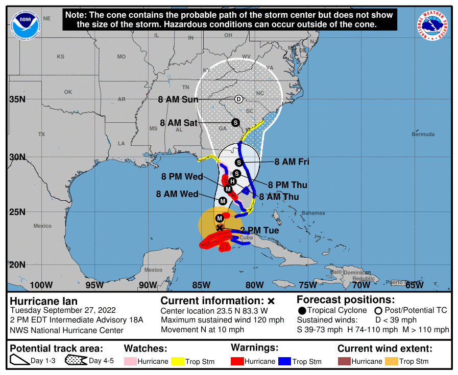
Tuesday, September 27, 2022 @ 2:45 PM –
Hurricane Ian Update From the Charleston National Weather Service
As of the 2pm update, Hurricane Ian is located about 265 miles South of Sarasota, FL, and has maximum stained winds of 120 MPH, moving north at 10 MPH.
Tropical Storm Watch and Storm Surge Watch Issued for our Area
A Tropical Storm Watch means tropical storm-force winds are possible somewhere within this area within the next 48 hours.
A Storm Surge Watch means life-threatening inundation, from rising water moving inland from the coastline, is possible somewhere within this area within the next 48 hours.
Tropical cyclone Ian will bring impacts to the area later this week into the weekend.
Wind Threat & Potential Impacts
Timing: Tropical Storm Force Wind Gusts could begin along immediate coastal areas/barrier island by Thursday, then all areas within rain bands Thursday night through Saturday
Potential Impacts: Scattered power outages due to downed limbs/trees possible
Potential Impacts: Significant flooding of lowlying/poorly drained areas
Tornado Threat & Potential Impacts
Timing: Mainly Friday into early Saturday
Potential Impacts: Isolated damage to trees, power lines and mobile homes; Isolated power outage
Please keep a close eye on the weather, as conditions can change quickly. For the latest forecast please visit https://www.weather.gov/chs.
Thursday, September 27, 2022 @ 5:00 AM –
Hurricane Ian will Likely Bring Impacts to the Area Late Week into the Weekend
Overview
Hurricane Ian will emerge from Cuba into the eastern Gulf today and will track toward the western Florida coast. Ian is expected to impact the local area later this week into the weekend. The forecast track remains somewhat uncertain, but the probability for heavy rain, coastal flooding and gusty winds is increasing.
Timing
The greatest impacts are likely to occur Thursday night into Saturday.
Hazards & Impacts
Rainfall: Rounds of moderate to heavy rainfall are likely Thursday night through Friday. Locally heavy rainfall could result in flooding, especially in low lying and poor drainage areas.
Coastal Hazards: The risk for coastal flooding will increase with the high tides beginning on Wednesday. Tides could reach moderate to major coastal flood levels Thursday morning, Thursday evening into Saturday. Any rainfall that coincides with high tide will exacerbate coastal flooding.
High surf, dangerous rip currents, and beach erosion are expected.
Winds : Gusty winds, possibly to tropical storm force, are expected to develop Wednesday night through Friday. Winds will be highest over the coastal waters and along the immediate coast. Gusty winds and saturated ground could contribute to localized downed trees.
Tornadoes: Isolated brief tornadoes/waterspouts are possible late Thursday night into Friday.
Please keep a close eye on the weather, as conditions can change quickly. For the latest forecast please visit https://www.nhc.noaa.gov/#Ian.