Overview
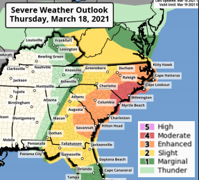
A strong cold front will move through the region tonight bringing a threat of severe thunderstorms during the afternoon across Southeast South Carolina and Southeast Georgia. The Storm Prediction Center highlights much of the area within an “ Enhanced Risk ” for severe weather. Confidence is high for the potential for damaging wind and isolated tornadoes.
Timing
- Severe Thunderstorms:
- Noon to 4 PM across inland areas, mainly west of I-95.
- 2 PM to 6 PM across coastal areas, mainly east of I-95.
- Note: Actual storms are expected to last 1-2 hours once they hit your region.
Impacts
- Damaging Winds: Wind gusts in excess of 58 mph could down trees and power lines and cause some structural damage and power outages.
- Tornadoes: A few tornadoes possible (some could be EF2 or greater).
- Hail: 1+ inch diameter hail could cause damage to vehicles and sensitive vegetation.
Click here to visit the National Weather Service website for the most recent weather updates.
—